
Survey Data
Reg No
15701509
Rating
Regional
Categories of Special Interest
Architectural, Scientific, Technical
Original Use
Bridge
In Use As
Bridge
Date
1775 - 1785
Coordinates
296787, 148855
Date Recorded
08/10/2007
Date Updated
--/--/--
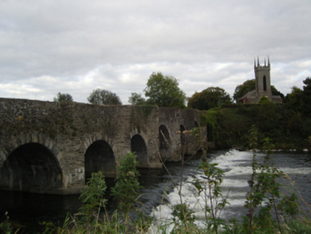
Description
Eight-arch road bridge over river, built 1780. Damaged, 1923. Part creeper- or ivy-covered coursed rubble stone walls centred on triangular cutwaters-cum-pedestrian refuges to piers with schist soldier course coping to parapets. Series of eight round or segmental arches with schist-spaced cut-granite voussoirs. Sited spanning River Slaney with unkempt banks to river.
Appraisal
A bridge representing an important component of the later eighteenth-century civil engineering heritage of County Wexford with the architectural value of the composition, one attributed to the Oriel Brothers of Hampshire (Duffy 2006, 80-1), confirmed not only by construction in unrefined local fieldstone offset by granite dressings demonstrating good quality workmanship, but also by the elegant "sweep" of the arches making a pleasing visual statement at a crossing over the River Slaney: meanwhile, a discreet benchmark remains of additional interest for the connections with cartography and the preparation of maps by the Ordnance Survey (established 1824).