
Survey Data
Reg No
20907133
Rating
Regional
Categories of Special Interest
Archaeological, Architectural, Technical
Original Use
Bridge
In Use As
Bridge
Date
1710 - 1750
Coordinates
141416, 72346
Date Recorded
01/02/2010
Date Updated
--/--/--
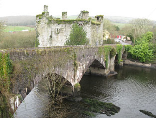
Description
Four-arch road bridge over River Lee, built c.1730, incorporating fabric former numerous repairs and alterations. Pair of round-headed arched to northern section, and pair of pointed arches to southern section. Rubble limestone walls with roughly dressed voussoirs, solider copings to parapets, and V-cutwaters to both elevations.
Appraisal
Set at an important crossing point, the bridge and adjoining tower house make a striking addition to the architectural heritage. Formerly spanning two channels of the River Lee, the water level was raised by the creation of the Lee Valley Hydro Electric Scheme in 1956. A bridge was indicated on this site in the Down Survey of 1656, and was described as a timber bridge in the Civil Survey of 1654-6. The current stone structure incorporates fabric from several building campaigns, as sections of the bridge were washed away and rebuilt during the eighteenth and nineteenth centuries. The existing southern arches were added c.1855, while the northern arches would appear to date from an earlier time.