


Survey Data
Reg No
30308001
Rating
Regional
Categories of Special Interest
Architectural, Technical
Original Use
Mill race
Date
1820 - 1840
Coordinates
129212, 226201
Date Recorded
24/07/2008
Date Updated
--/--/--
Description
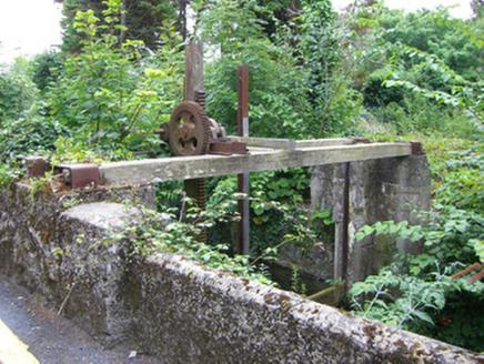
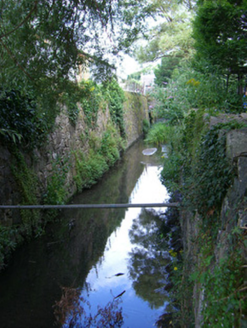
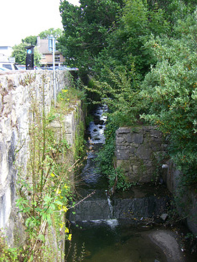
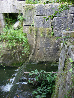
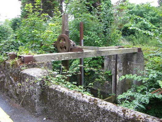
Canal/mill race, built c.1830, running (south) from beneath swimming pool car park (recent development) through pair of recent concrete square pipes into stone-lined basin, now heavily overgrown. Large concentration of waste and debris to basin and environs. Unclear if base is puddled or stone-lined. Canal enters recent tunnel (20m to south) with rubble stone block bridge (north end) which has been extended (south) having granite block voussoirs to arch and rubble stone parapet. Canal continues below street (30 m south), tunnel terminating with recent rubble bridge façade with camber arch having limestone voussoirs and keystone, bridge extended and faced (underside most likely concrete). Banks of cutting continue to be lined with rubble and block stone lining having occasional lengths of concrete coping, repairs and occasional drains feeding cutting (mostly recent). Fabric of basin walls improves markedly (30m south) especially on west bank where rubble stone is replaced by cut blockwork of similar quality to lock basins. Channel then widens just north of next bridge having limestone voussoirs and rubble stone parapets. Water level also drops at this point by half a metre as water flows over concrete or stone weir (moss obscures view) with traces of now absent sluice gate indicated by presence of various niches in basin walls. North of sluice mechanism is single-span rubble stone block road bridge, formerly humped back but now flattened having tooled limestone voussoirs and recent rubble stone and concrete parapets to tarmac surface, widened with concrete lintel to south face. Basin heavy with sediment and rubbish at this point and walls change becoming battered as canal narrows slightly changing back to roughly coursed rubble stone structure with concrete coping. Canal continues (south) cutting getting steadily shallower beneath rubble stone foot bridge with parapet and tooled limestone voussoirs becoming more overgrown, batter of wall becoming shallower. Canal enters paired concrete culvert (c.5m) with rubble stone surround and coping to tarmac foot and road bridge. Modern bridge (south) with reinforced concrete supporting piers alongside canal with resulting reinforcement and rebuilding of banks. Two recent bridges present as basin returns to original rubble block fabric. Canal exits beneath modern NUI building area (heavily overgrown) before entering another concrete pipe culvert with recent parapet and surround façade of rubble stone block work. Culvert runs for approx 12m before re-entering cutting via pipe at another rubble façade. Banks far less well defined here, for stretches comprised of carved bedrock with occasional stretches of rubble stone block work becoming more frequent towards south until basin is once again fully lined with rubble blocks and deep cutting once more. Final stretch of canal is of rubble stone work again before running under final stone block construction bridge with limestone voussoirs. Canal splits with inlet from Lough Corrib to east feeding in via timber and iron sluice gate (formerly narrow block-lined lock basin. Main flow, however, continues south where water flow from canal and Lough flow underneath blockwork bridge which resembles large millrace, having battered north elevation with remains of attached steel footbridge which is now unsafe.
Appraisal
This extensive cutting and the associated bridge structures are important reminders of Galway's industrial past. The fine masonry work demonstrated in the basin walls and bridges is of very high quality in places and although now disused it makes a significant contribution to the architecture of the area.