
Survey Data
Reg No
30330001
Rating
Regional
Categories of Special Interest
Architectural, Technical
Original Use
Bridge
In Use As
Bridge
Date
1750 - 1770
Coordinates
150060, 263941
Date Recorded
30/09/2009
Date Updated
--/--/--
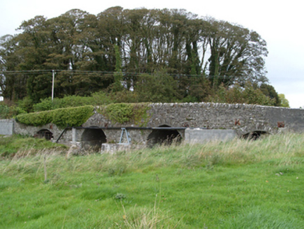
Description
Four-arch random rubble limestone road bridge, built c.1760, over Sinking River. Slightly pointed central arches flanked by segmental arches. Thin rubble stone voussoirs to arch rings, gunnelling to arch soffits. Flat-fronted concreted cutwaters. Metal bracing clamps to either side of each arch. Random rubble limestone spandrels and parapets, latter with stones laid on edge. Section of parapet to south-west replaced with concrete block and flat coping. Recent concrete blockwork supporting pipework to south-west elevation. Random rubble limestone walls to adjoining fields.
Appraisal
The simply detailed road bridge, carrying traffic over the Sinking River, is a good example of the achievements of eighteenth-century local craftsman. It retains its original form and has been important in maintaining transport links between Dunmore and Claremorris for over two centuries.