
Survey Data
Reg No
31303701
Rating
Regional
Categories of Special Interest
Architectural, Scientific, Technical
Original Use
Bridge
In Use As
Bridge
Date
1809 - 1838
Coordinates
100921, 315746
Date Recorded
21/01/2011
Date Updated
--/--/--
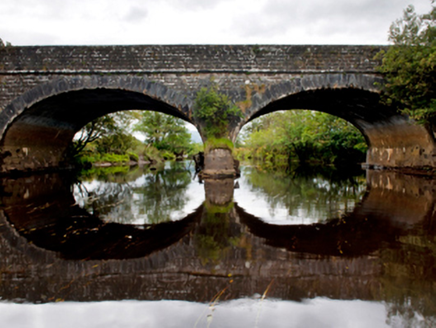
Description
Two-arch road bridge over river, extant 1838. Tuck pointed coursed cut-limestone walls centred on tooled limestone ashlar rounded triangular cutwater to pier having grass-covered capping with lichen-covered tooled cut-limestone "Torus" stringcourses supporting parapets having lichen-covered tooled cut-limestone coping. Pair of elliptical arches with drag edged tooled limestone ashlar voussoirs. Sited spanning Deel River with unkempt banks to river.
Appraisal
A bridge identified as an important component of the early nineteenth-century civil engineering heritage of County Mayo on account of the connections with the development of the so-called "Central Road" by William Bald (c.1789-1857), cartographer and engineer (appointed 1809), with the architectural value of the composition, one recalling the Bald-designed Bellacorick Bridge (1820-1), Bellacorick (see 31302702), confirmed not only by the "sparrow pecked" sheer limestone dressings demonstrating good quality workmanship, but also by the elegant "sweep" of the arches making a pleasing visual statement at a crossing over the Deel River: meanwhile, a discreet benchmark remains of additional interest for the connections with cartography and the preparation of maps by the Ordnance Survey (established 1824).