Survey Data
Reg No
40905384
Rating
Regional
Categories of Special Interest
Architectural, Technical
Original Use
Bridge
In Use As
Bridge
Date
1770 - 1810
Coordinates
222255, 415197
Date Recorded
18/11/2013
Date Updated
--/--/--
Description
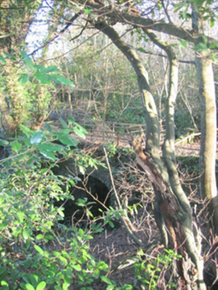
Single-arched bridge, built c. 1790, carrying pathway between ruinous site of Castle Wray (see 40905304) to former walled garden (see 40905381) over small unnamed stream following into Lough Swilly adjacent to the east. Now out of use. Round or segmental-headed arch with roughly dressed stone voussoirs; squared rubble stone construction to arch barrel. Squared and rubble stone construction to spandrels and abutments. Dwarf rubble stone parapets over having metal or timber railings over. Earthen or overgrown deck. Located well back from road in former Castle Wray demesne a short distance to the north-east of the site of the main house, and to the south-west of former walled garden (see 40905381).
Appraisal
This simple but appealing single-arch bridge, probably originally dating to the end of the eighteenth century, retains its original form and character despite being now out of use. It is sited in the former demesne of Castle Wray, and was constructed to carry a laneway between the main house (now in ruins; see 40905304) and the former walled garden (see 40905381) to the north-west of the house. It is robustly-constructed in local squared rubble stone masonry, and its continued survival and use stands as testament to the quality of its original construction, and of the skill of the masons involved. This largely forgotten feature now acts as an historical reminder of the Castle Wray and the Wray family who built it. The main house was originally built by the Wray family, one of the most important family of landowners in the county during the seventeenth century into the nineteenth century. The Wrays acquired the site during Plantation times, c. 1610, and built the original house shortly afterwards, which was a house ‘of lime and stone within its protecting bawn’. This was replaced in the eighteenth century by a Georgian two-storey house on or near the same site. The house appears to have been extended around 1840 (Ordnance Survey maps). The house remained in the Wray family until c. 1840 when it passed into the ownership of the Mansfield family. It was the home of a Capt. Ralph Mansfield in 1846, and a Col. Francis Mansfield in 1881 and 1894 (all Slater’s Directory). The house was apparently unoccupied in the 1930s, and was subsequently demolished.

